Climate, Topography and Drainage Maps of Africa

This website is out of date and will shortly be deleted

Click here for new website and latest maps .

Palaeoclimate, Paleotopogography and Palaeodrainage Maps of Africa

UNDER CONSTRUCTION
An ongoing project using the plate model of Colin Reeves (www.reeves.nl)
Comments welcomed
CLICK MAPS TO EXPAND
watch at  https://www.youtube.com/watch?v=YoNYyLGlxjA

Methodology

The interpretation of paleotopography decreases in confidence with increased age. For Neogene and Oligocene intervals, portrayals are primarily based on interpretations of the age of existing topography, backtracked through time (e.g. Paul et al, 2014), often using river profiles. Marked changes in topography around the early Oligocene, evidenced for instance by sedimentation rate profiles, mark the limits of this technique and a step change in confidence. For Paleogene and Mesozoic intervals, apatite fission track derived evidence for rapid cooling  becomes the primary technique. Beyond the base of the Cretaceous, there are few AFTA dates and any interpretation is speculative: dedicated maps are not therefore compiled here.  The AFTA literature for Africa has been scanned and arrows are added on the maps for when minor and major uplift is evidenced. Again, this technique has a lower stratigraphic limit around the middle of the Cretaceous, as apatite clocks were generally set after this time  In general, AFT ages around Africa get older in a clockwise direction commencing on the Red Sea margin, and this is taken as indicating that the average age of uplift and topography gets older in the same clockwise manner. Other more indirect lines of evidence used throughout the stratigraphic section include offshore and internal sink sedimentation rates, the likely effects of tectonics such as the building of mountain belts, rift shoulders and volcanically evidenced mantle plumes, evidence from maturity data such as vitrinite reflectance for deep erosion, extrapolation of coastal monoclines and of erosion surfaces and the frequency of marine transgressions.  All paleotopography shown is relative, with no elevation figures implied.

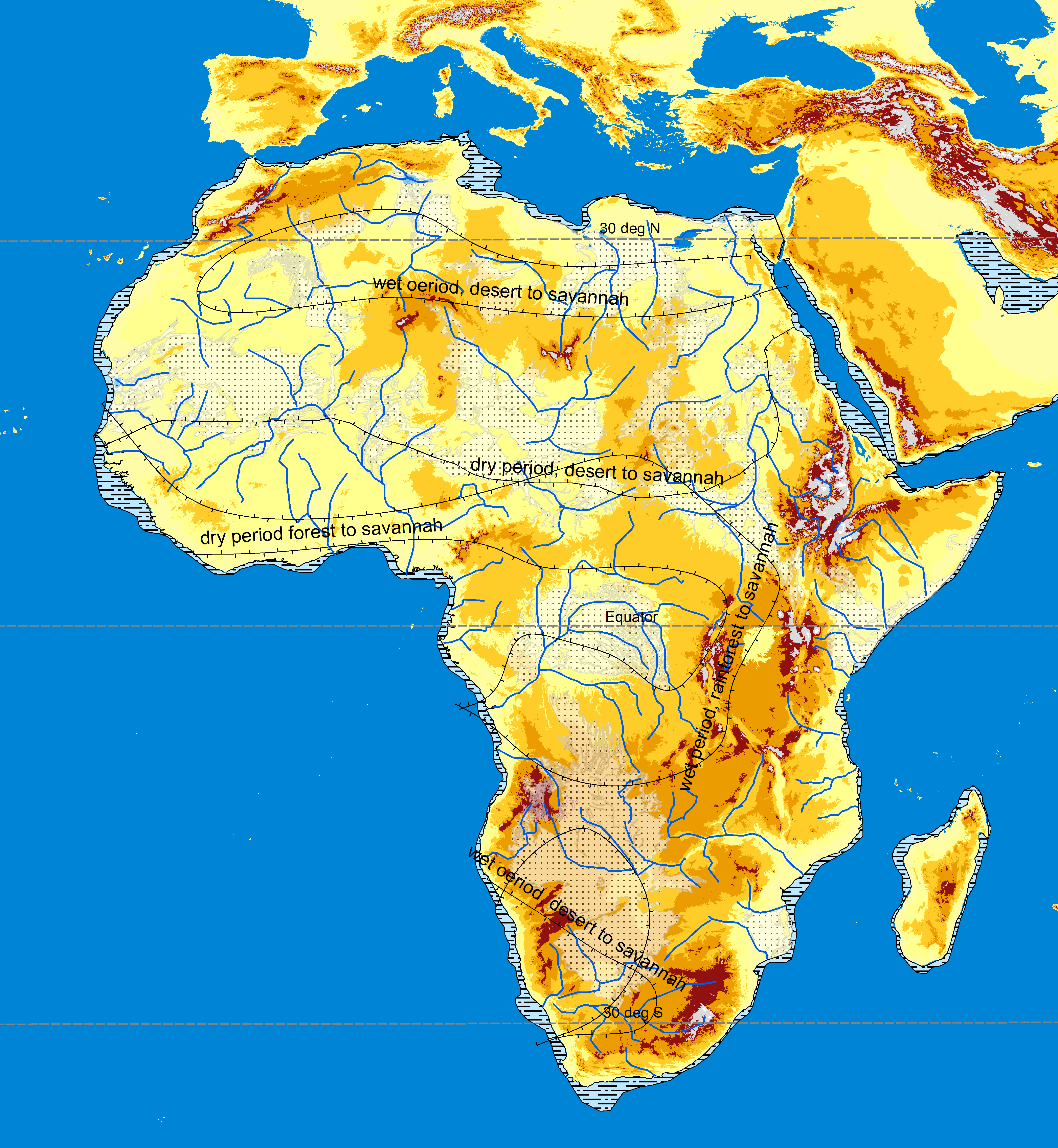
The assessment of paleodrainage again relies ideally on agreement from a number of techniques. As for paleotopography, it is possible to model modern rivers back as far as Late Oligocene by considering the maturity of their profiles (Paul et al, 2014 ). For all intervals, it is assumed using modern analogues (Snedden et al 2018) work that there will be a rough relationship between sedimentary rate, volume and the length of the river system (assuming a wet climate). Offshore sedimentary rates calculated using the methodology presented in Macgregor (2012) are thus used to interpret relative sizes of catchment areas. Two examples of this are the very high sedimentation rates seen relative to other depocentres in the Early Cretaceous offshore Western Sahara and the Niger River, particularly in the Paleogene. Both rivers have to be assumed to be draining very large hinterlands at that time, and in the case of the Paleogene Niger, it is assumed that this must be draining the Congo Basin, as no substantial thickness of sediment is seen at this time offshore Angola and Gabon at that time. Marker mineral work is available only locally, including for the Nile (Fielding et al, 2018 ),  in East Africa (Zircon Fission Track Data of Geotrack, unpublished) and Southern Africa (origins of diamonds and ilmenites ). Unpublished work by TotalEnergies is used on the Equatorial Margin (Ye, 2020). This is combined with other evidence, e.g. in East Africa where paleotopographic evidence, particularly AFTA and maturity data all support a model whereby a line close to the Present Day watershed separated west and east draining rivers as far back as the Early Cretaceous.  

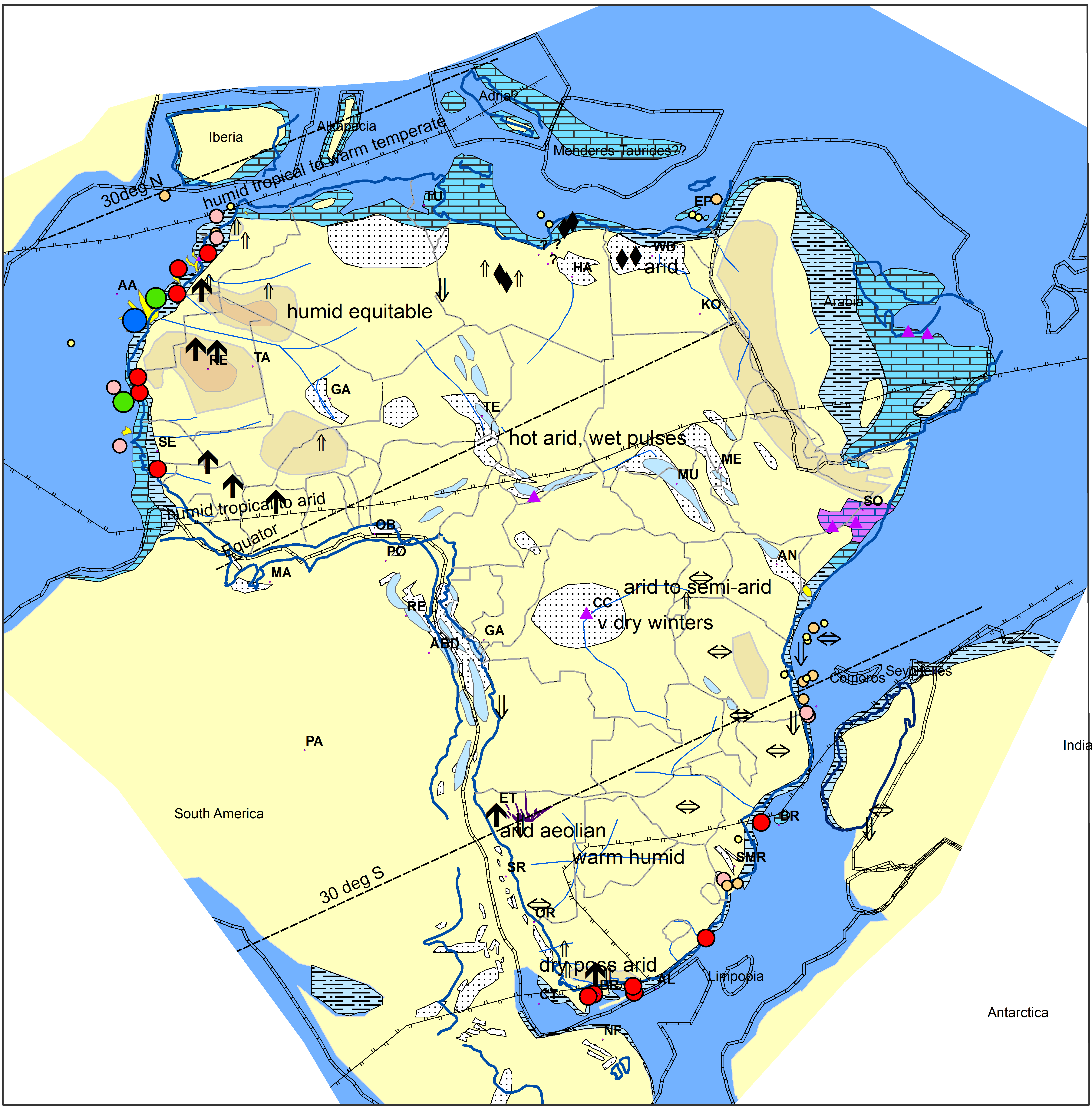
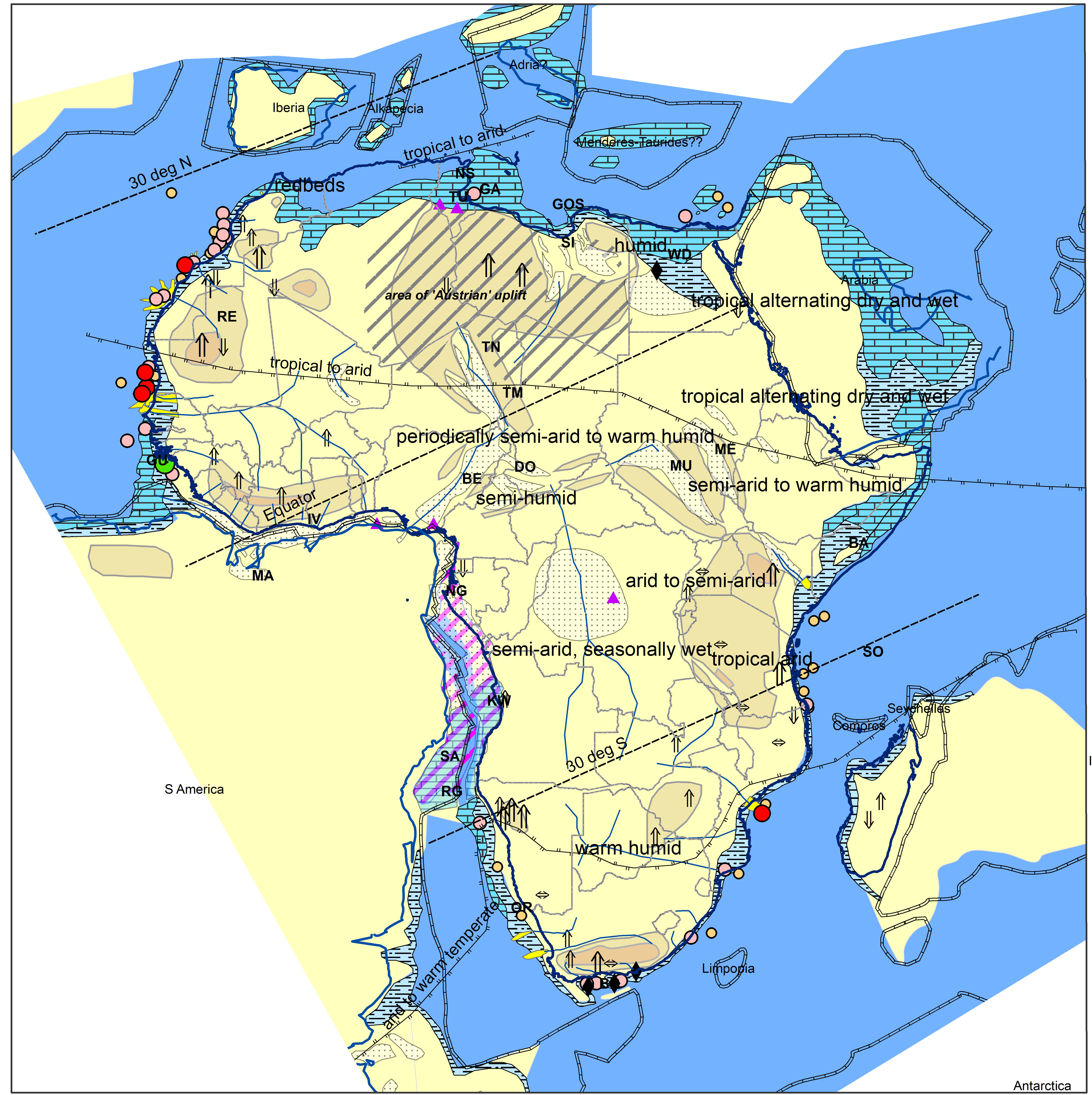
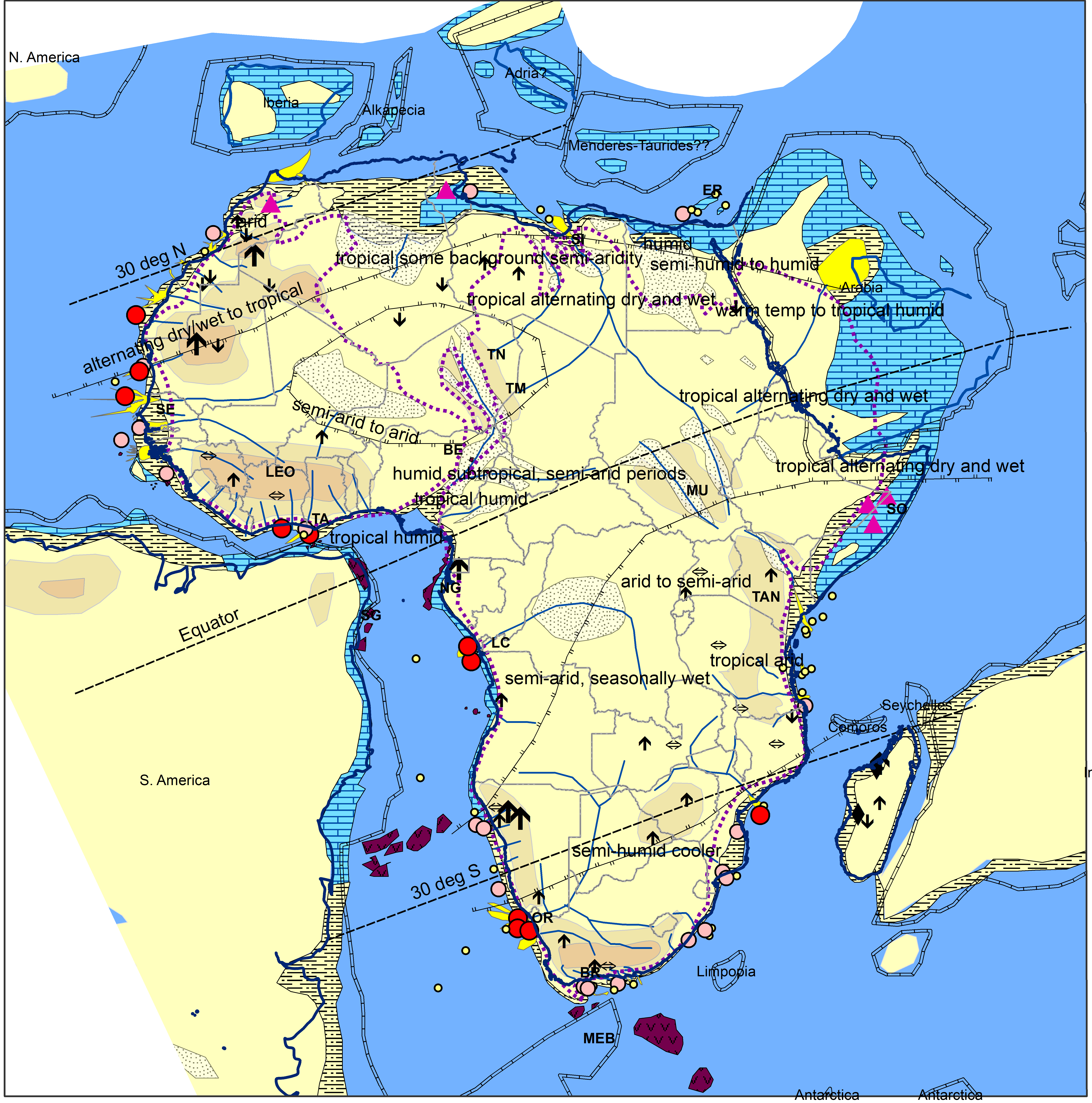
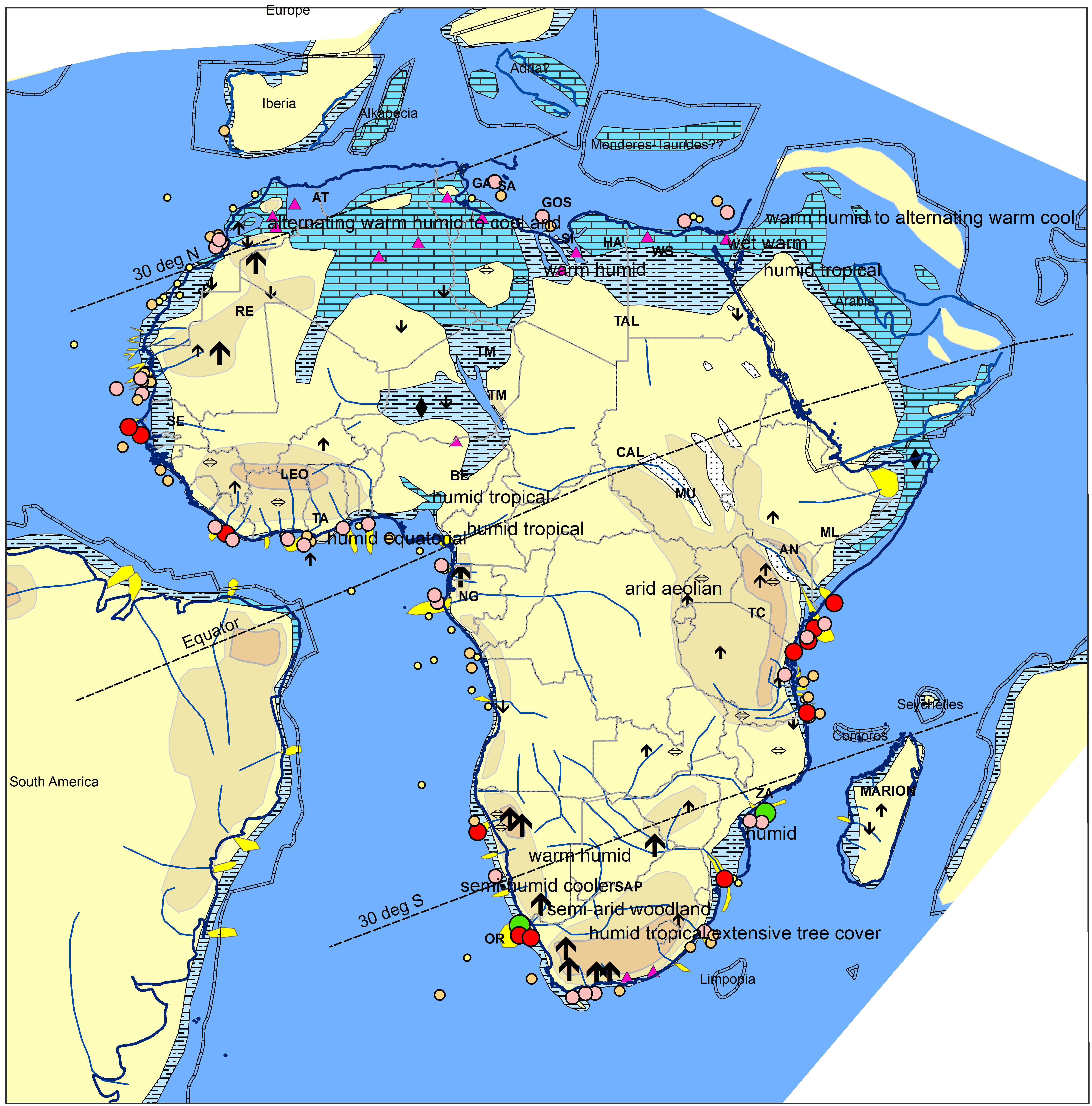
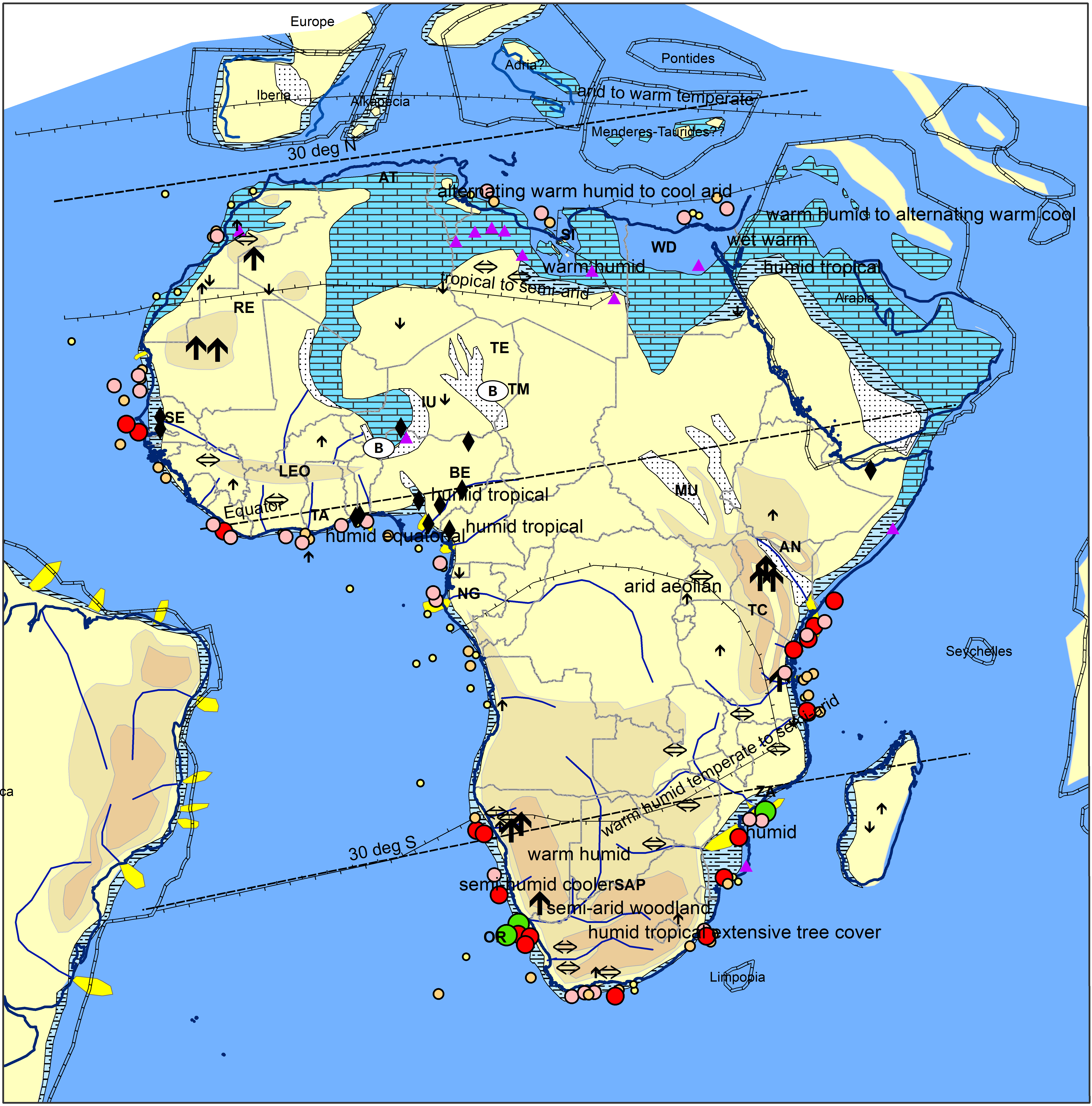
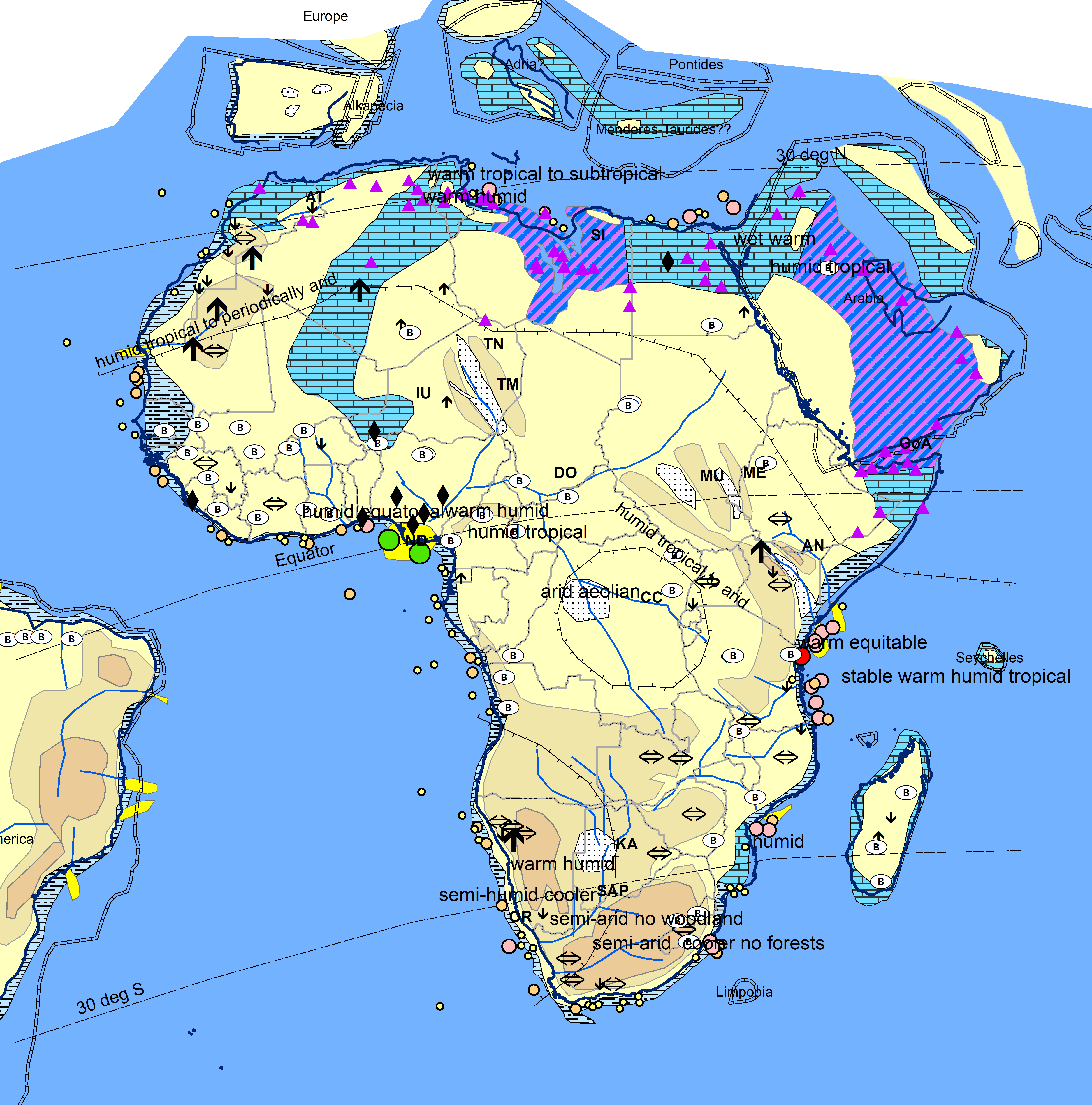
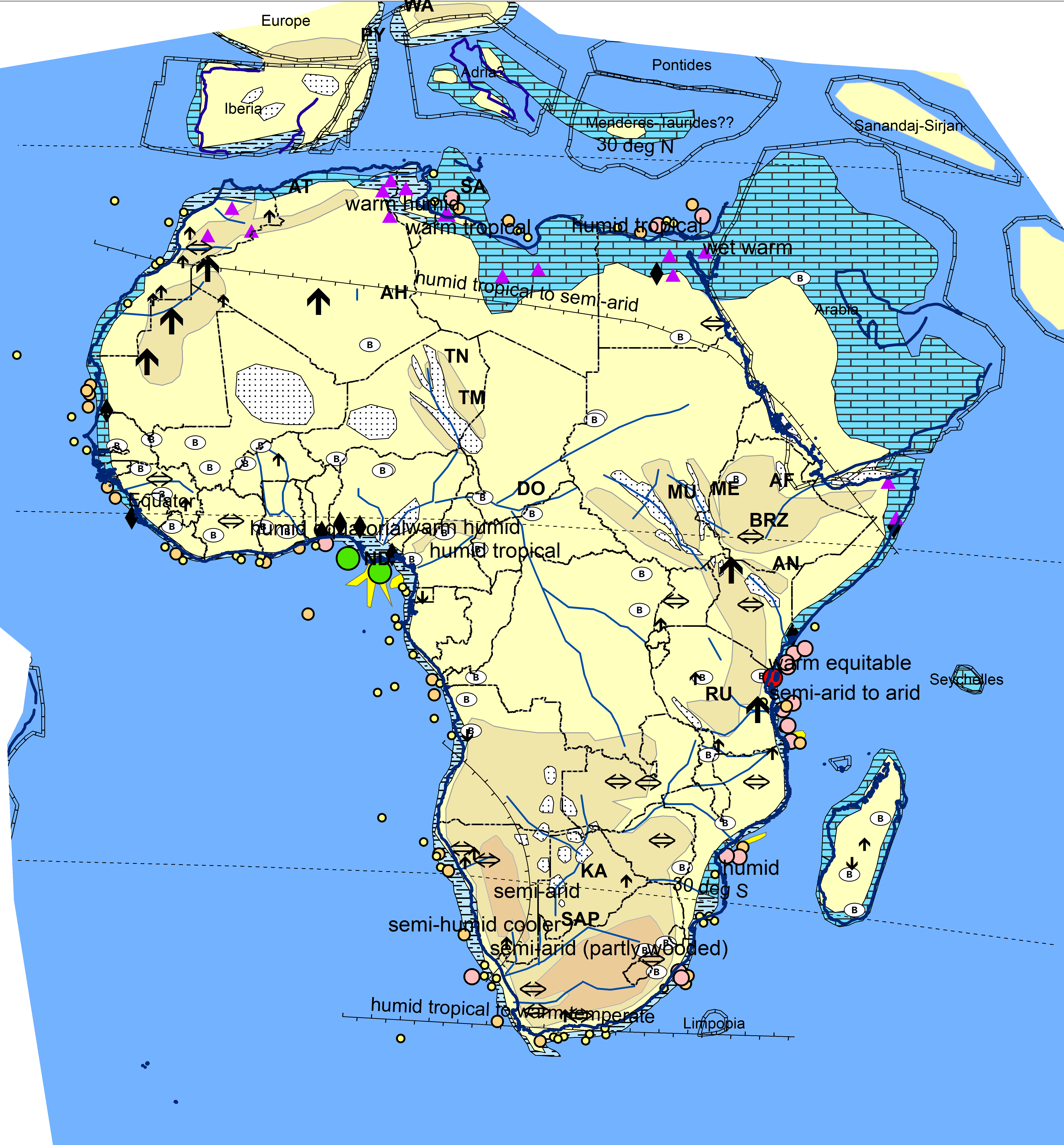
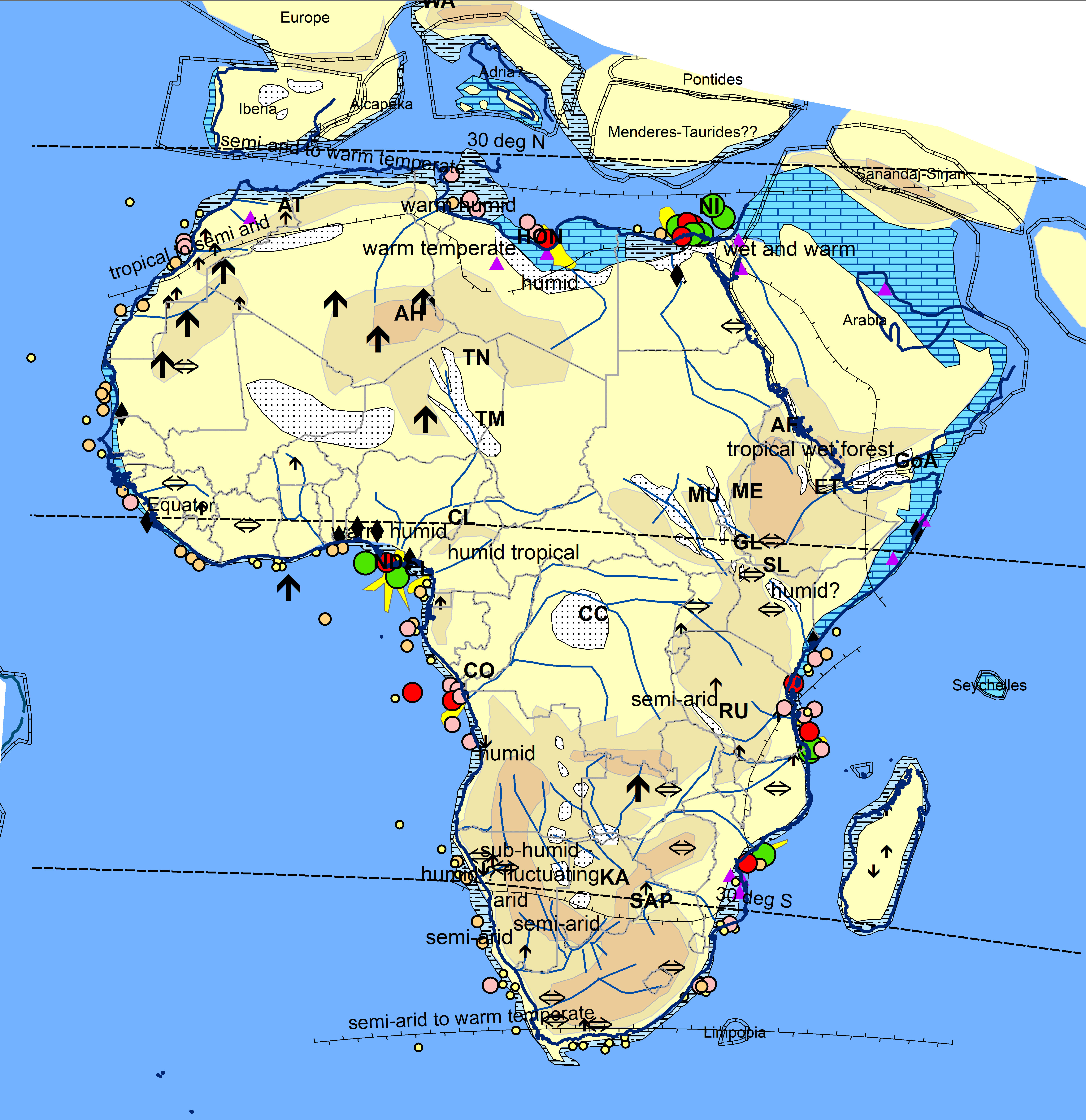
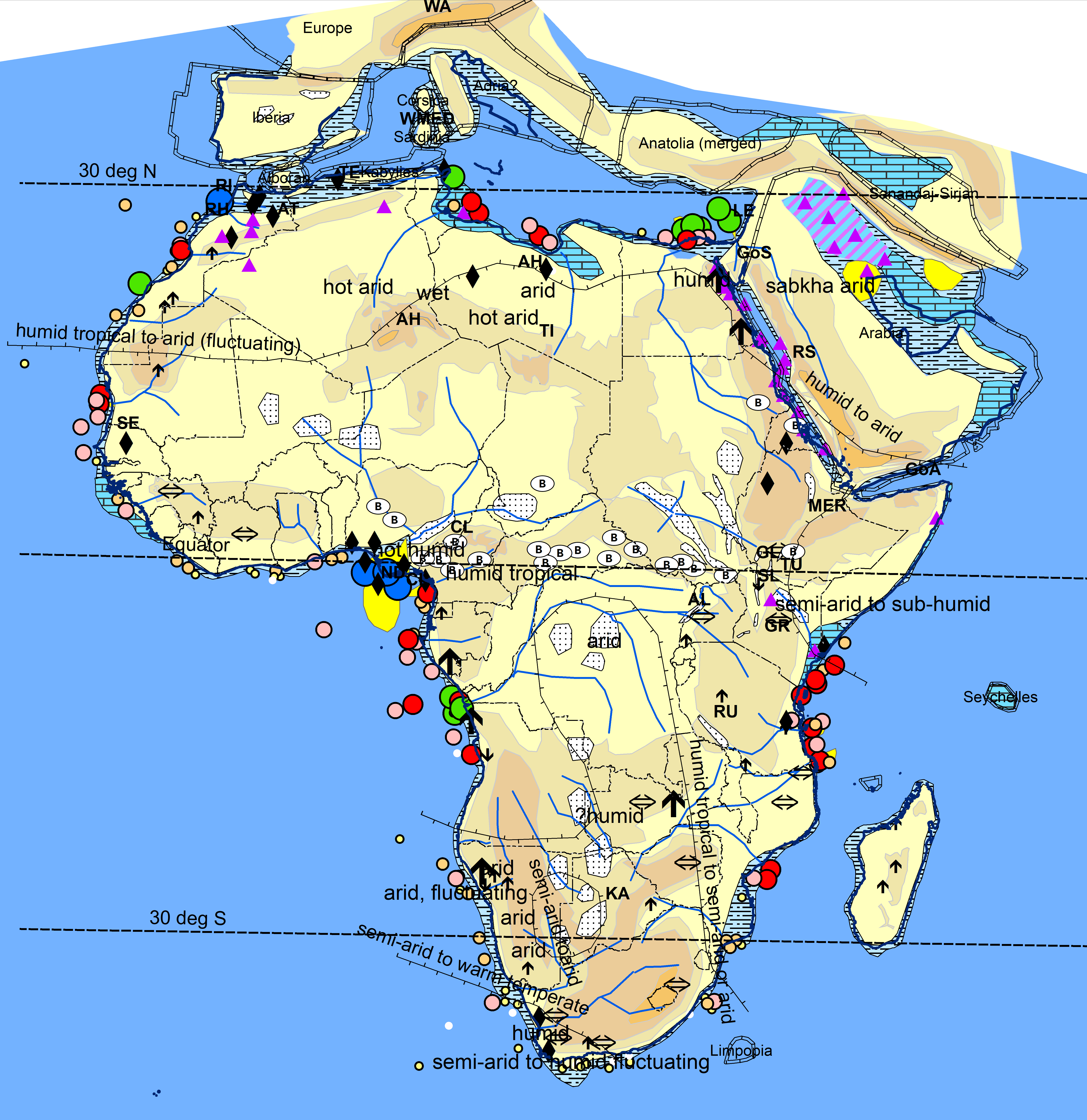
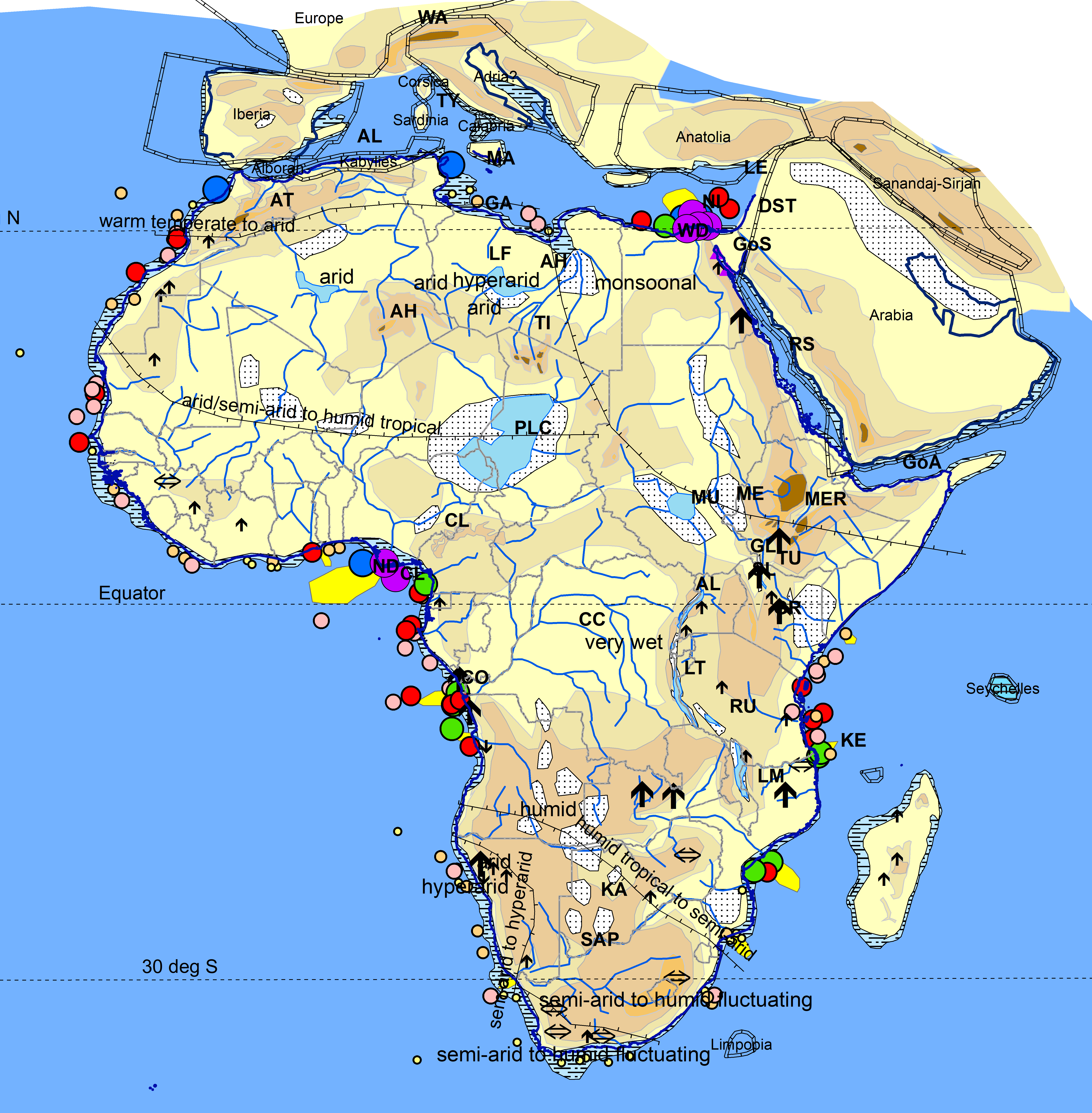
Paleoclimate has been assessed by compiling rock derived interpretations and then contouring round these. The literature has been searched for sedimentologically derived interpretations of paleoclimate and these are input as point/comments on the maps. Occurrences of climate indicative lithologies such as evaporites, coals and bauxites are also shown. Roughly 80 such interpretations have been compiled, with good data over North, parts of West and South Africa and less data elsewhere. The interpretations of the authors concerned have not been audited in any way. Labelled lines are then input to differentiate climatic zones. Where the data points are sparse, these boundaries take account of trends through adjoining continents (Boucot atlas). A low sedimentation rate associated with a high degree of topography is assumed to indicate an arid climate, while a wet climate is necessary to support a high sedimentation rate


Valanginian 135Ma

Clastic sedimentation rates rise substantially on NW African margins north of Senegal. Around 400,000 cubic kilometres of sediment (compacted) are deposited between the Berriasian and Barremian in the Aaiun (AA) Delta, at rates comparable to the Cenozoic Nile and Niger systems  Based on the scaling relationships of Somme et al (2009) a catchment area of the order of 106 km3 is required as well as a wet climate. AFTA data indicate a wide area of uplift at this time, extending into the Taoudenni (TA) basin. A carbonate bank continues to form on the Senegal margin.  

There is paleofloral (Burgoyne, 2005) and other evidence for a general wettening of the climate of north Africa around this time, despite only minor movements in paleolatitude belts. Warm generally dry conditions characterise southern Africa

Aptian 118Ma

Within Southern Africa, Moore and Larkin (2009) interpret the first phase of uplift of the southern Africa plateau, centered on the Cape Fold Belt. As the intensity of erosion in the Agulhas basins increases eastwards, this may be driven by the Maurice Ewing Bank (MEB) passing on the Agulhas Fault. Hunt (2021) presented a model to suggest that a river which originally flowed out further south was diverted by this uplift to feed the first reservoir sands of the Orange Basin (OB)

Late Albian 102Ma


A sharp change occurs on the Senegal margin from carbonates to clastics in the Early Albian . New drainage systems seem to be sourced from the uplifted Leo Massif (LE) where a N-S watershed is evidenced by mineralogical data (Ye et al, 2021). The massif may have been formed by transpression as South America departs from Africa. The Orange (OR) river has become the most significant depocenter of Africa and commences a progradation at this time.  A major eustatic rise occurs in the early Cenomanian that causes major transgression, particularly in north and north-central Africa, with Tethyan and South Atlantic waters then connected through Niger and the Benue Trough (BE). The extent of this Cenomanian transgression, largely taken from Sahagian (1988) is portrayed on this map as a purple line

.

Santonian 86Ma

A major expansion of the South African plateau occurs between 93-66Ma (Baby et al, 2018). Effects are also seen on AFTA profiles as far interior as Zambia (M. Daly pers comm). The broad nature of the uplift and the association with alkaline magmatism seemingly point to a mantle origin. The uplift and increasingly wet climate cause an increase in clastic sedimentation rate in various outlets, including the Orange (OR) and Zambezi (ZA).  AFTA data and increasing sedimentation rates also indicate the uplift of a large area of Kenya and Tanzania (Foster and Gleadow, 1996), including the deeply eroding rift shoulders of the active Anza Rift (AN, Morley et al, 1997). Unpublished Zircon Fission Track Data from Tanzanian sediments indicate this high likely formed the African watershed. The westwards drainage was towards Gabon.

High sea levels have persisted since the Cenomanian. Due to rapid fault subsidence at this time, deep marine strata are developed in the interior of Africa in the Termit (TE) Basin (Zhou et al, 2017) . However inversion in the Benue (BE) Trough has likely blocked the connection between the Tethyan and South Atlantic oceans (Bonne, 2014). Wet climates are now established over much of the continent, with arid conditions confined to the interior in the south and to northwest Africa

Maastrichtian-Danian 65Ma

The South African plateau has been uplifted between 93-66Ma (Baby et al, 2018) so topography has expanded considerably since the Santonian. A sharp reduction occurs in the Danian in sedimentation rates in all surrounding sinks. This is assumed to be due to a sharp drying of the climate in that region, which essentially freezes the topography established at that time. AFTA fission track ages on the Tanzanian Craton (TC) and Anza rift shoulders also peak around this time, suggesting maximum topography.  For the first time, a river is interpreted flowing down the Benue Trough (i.e. a paleo-Benue, which is the dominant branch of the Niger even today)

In North Africa the Late Cretaceous transgression has become even more advanced, with the shoreline reaching into Sudan (Selim, 2015) and periodically into the Iullemmeden (IU, Moody 1997) Basin of Niger. This results in the deposition of large volumes of chalk.

Ypresian 50Ma

The widespread nature of bauxites suggest very slow erosion over the Paleocene to Eocene, leading to the development of a bevelled (though not necessarily low) surface, often termed the ‘African Surface’. These are taken as indicators of an expanded zone of a warm humid ‘drizzly’ climate, covering most of the plate, leading to generally low sedimentation rates. Northern Africa appears to have been topographically low, as evidenced by the dominance of carbonates, which indicate clear clastic free water, and the wide extent of marine transgressions, e.g. into the Iullemeden (IU) Basin. Northern Africa, Arabia and the Horn of Africa are rich in evaporites, indicating at least periodic aridity. Sedimentation rates are relatively low on the margins of the continent, with the notable exception of the Niger Delta (ND), which is thought to have been initiated in the Paleocene. The very low sedimentation rates elsewhere on the West Africa margins would suggest that the Niger and Benue systems might be draining large regions that were later captured by younger rivers, including the Nile and the Congo This is supported by observations of northwards drainage in fluvial strata in the Cuvette Centrale (CC). The Orange (OR) depocenter shows a sharp reduction in sedimentation rate at the end of the Cretaceous, which is thought to be linked to an increase in aridity. .

Priabonian 35Ma

 The first Ethiopian volcanics are the first of a series of volcanic events associated with the development of topographic swells. Elsewhere, topography and drainage are interpreted to be similar to that interpreted on the Ypresian map. Carbonate, occasionally evaporite, facies dominate in north African margins while slow sedimentation of argillaceous material occurs on southern shelves. The Niger again is the dominant depocentre, characterised by a thick shale prone sedimentary pile

Rupelian 30Ma

 The topography of Africa starts to undergo changes at this time, with the commencement of the formation of the ‘basin and swell’ topography of Africa and the modern river systems associated with this new topography. The first swells that start to form at this time include the Ahaggar (AH), the Afar plume (AF) and a curving axis through the northern part of the South African Plateau (SAP). The Ethiopian traps (ET) erupt on the Afar Plume from 30-31Ma. Many offshore basins show unconformities at varying levels in the Oligocene, indicating relative uplift of the basin margins (e.g. Angola). These ?mantle cored movements created internal depressions between the growing swells into which rivers initially drained : these then found outlets to oceans through earlier rifts (e.g. Niger/Benue), lines of weakness such as the extension of fracture systems (? Congo, CO) or by cutting gorges through rising topography (Nile, NI). A global climatic change occurs at the base of the Oligocene. The warm temperate belt now seems to extend southwards to cover parts of northern Africa, with a diminishment of the frequency of evaporites The humid tropical belt regresses northwards in southern Africa, where increasingly semi-arid conditions set in as part of a drying trend which continues to Present Day

Langhian 15Ma

The African basin and swell system is now becoming more pronounced, particularly in NE Africa, where the initiation of additional swells are suggested by volcanic ages and by increasing sedimentation in the Nile depocenter. The rising Red Sea rift shoulders also supply significant sediment to the Nile system. The Benue/Niger (ND) system now progrades onto oceanic crust and the Congo progressively switches northwards. Miocene uplifts are interpreted along the West African margin from Equatorial Guinea southwards. Volcanism continues in Ethiopia, now becoming more areally limited and shield like. Cameroon Line (CL) volcanism is extended onto oceanic crust. The climatic belts now look familiar to Present Day. A belt of bauxites run along the paleoequator. The main exception seems to be North-East Africa, where wet, possibly monsoonal conditions are interpreted.

Zanclean 5Ma

Uplift occurs over large parts of Central and Southern Africa from 11-3Ma. There is considerable debate over the magnitude of Neogene uplift of the South African Plateau (SAP), with researchers essentially falling into two camps, one considering that the plateau is essentially a Late Cretaceous feature and the other that there was also kilometre scale Late Neogene uplift. Stanley et al (2020) shows that both models remain possible with the available evidence and the maps shown here take a middle ground to this debate. Rivers are now resembling their current forms, though a few connections are yet to be made to current upper headwaters. The Pliocene shows a significantly changing climate with probable significant short term variations. Many basins show peak sedimentation rates at this time, including the Niger and Nile, attesting to the wetter conditions compared to Present Day. North-east Africa again appears to be wet, while large lakes were developed periodically in Lakes Fezzan (FE) and Chad (PLC) . Late on in the Pliocene, increasing aridity will set in in both northern and southern Africa, with the current Sahara forming at 2.5Ma. .

Holocene 0Ma

Climates are now highly variable, following glacial and Milankovich cycles, with the Namibe (NA), Kalahari (KA)and Sahara deserts alternatively advancing and retreating in historical times.  Savannah climates are now especially well developed. Africa, particularly southern Africa, now contains the highest regions of high topography in the world that are not associated with plate boundaries, volcanism or collision. This anomalously high topography is concentrated along an NNE-SSW axis between the South African plateau and the Red Sea, including the unusually high and wide East African rift shoulders. Imaging of the mantle from S wave velocity analysis suggest that this is related to a mantle convection cell that rises from the lower mantle below South Africa to an eruption in the southern Red Sea.

Xxxx

Lorem ipsum dolor sit amet, consectetuer adipiscing elit. Donec odio. Quisque volutpat mattis eros. Nullam malesuada erat ut turpis. Suspendisse urna nibh, viverra non, semper suscipit, posuere a, pede.

Top 10 References


Boucot Arthur J. Xu Chen, Christopher R. Scotese, Robert J. Morley. “Phanerozoic Paleoclimate; an Atlas of Lithologic Indicators of Climate.” Concepts in Sedimentology and Paleontology 11 (October 2013)  https://pubs.geoscienceworld.org/sepm/books/book/1966/Phanerozoic-PaleoclimateAn-Atlas-of-Lithologic

Cairncross, B. (2001) ‘An overview of the Permian (Karoo) coal deposits of southern Africa’, Journal of African Earth Sciences, 33(3–4), pp. 529–562 https://www.researchgate.net/publication/222382935_An_overview_of_the_Permian_Karoo_coal_deposits_of_southern_Africa_Journal_of_African_Earth_Sciences_33_529-562